• Galleries
    • Africa
    • Antarctica
    • Asia
    • Australia
    • Europe
    • North America
      • North America
      • Mexico
      • Canada
    • South America
    • Middle East
    • World Maps
    • United States
    • U.S. Cities and States
      • Alaska
      • Arizona
      • California
      • San Francisco
      • Colorado
      • Florida
      • Hawaii
      • Iowa
      • Kentucky
      • Maine
      • Massachusetts
      • Michigan
      • Montana
      • Nevada
      • New York
      • Oregon
      • Pennsylvannia
      • Rhode Island
      • South Carolina
      • Texas
      • Utah
      • Virginia
      • Washington State
      • Wisconsin
      • Wyoming
    • National Parks
      • Denali Nat'l Park, AK
      • Glacier Nat'l Park, MT
      • Grand Canyon Nat'l Park, AZ
      • Rocky Mountain Nat'l Park, CO
      • Yellowstone Nat'l Park, WY
      • Yosemite Nat'l Park, CA
      • Zion National Park, UT
    • Pictorial maps
    • Timeline Maps
    • Mapping the Heavens
    • The Hysterical Maps
    • Military
    • Historic Ads
    • Oversized Maps
David Rumsey Map Collection

Cartography Associates

  • My Account
  • My Cart
  • Checkout
  • Log In
  • Help
  • Home /
  • Galleries /
  • United States /
  • Ta-Non-Ka's Indians of the paper country, 1942
Ta-Non-Ka's Indians of the paper country, 1942
* Required Fields
Product ID  :  002-8182000
$39.95
Landscape

Width:

Height:

Choose Cropping space on the image below

Style description

Caption

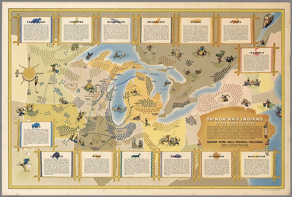
Ta-Non-Ka's Indians of the paper country. Badger Paper Mills, Peshtigo, Wisconsin. Maker of Ta-Non-Ka Mimo Bond. copyright 1942. Printed on Ta-Non-Ka substance 24.
Pictorial map of the Great Lakes region showing historical locations of Native American groups. Covers Minnesota, Iowa, Wisconsin, Illinois, Michigan, Indiana, Ontario, Ohio, Pennsylvania, and New York. Blocks of text arranged around the map provide a description of each group. Notes: "The Green Bay region of Wisconsin owes much of its rich Indian heritage to the Iroquois, who drove the countless thousands of Algonquin Indians to the shelter of its virgin forests and protecting the lakes ..."

  • Galleries
    • Africa
    • Antarctica
    • Asia
    • Australia
    • Europe
    • + North America
      • North America
      • Mexico
      • Canada
    • South America
    • Middle East
    • World Maps
    • United States
    • + U.S. Cities and States
      • Alaska
      • Arizona
      • California
      • San Francisco
      • Colorado
      • Florida
      • Hawaii
      • Iowa
      • Kentucky
      • Maine
      • Massachusetts
      • Michigan
      • Montana
      • Nevada
      • New York
      • Oregon
      • Pennsylvannia
      • Rhode Island
      • South Carolina
      • Texas
      • Utah
      • Virginia
      • Washington State
      • Wisconsin
      • Wyoming
    • + National Parks
      • Denali Nat'l Park, AK
      • Glacier Nat'l Park, MT
      • Grand Canyon Nat'l Park, AZ
      • Rocky Mountain Nat'l Park, CO
      • Yellowstone Nat'l Park, WY
      • Yosemite Nat'l Park, CA
      • Zion National Park, UT
    • Pictorial maps
    • Timeline Maps
    • Mapping the Heavens
    • The Hysterical Maps
    • Military
    • Historic Ads
    • Oversized Maps

Copyright 2018 Cartography Associates.

Copyright © 2018 Reprint Mint Privacy Policy

Powered by

Powered by Reprint Mint