• Galleries
    • Africa
    • Antarctica
    • Asia
    • Australia
    • Europe
    • North America
      • North America
      • Mexico
      • Canada
    • South America
    • Middle East
    • World Maps
    • United States
    • U.S. Cities and States
      • Alaska
      • Arizona
      • California
      • San Francisco
      • Colorado
      • Florida
      • Hawaii
      • Iowa
      • Kentucky
      • Maine
      • Massachusetts
      • Michigan
      • Montana
      • Nevada
      • New York
      • Oregon
      • Pennsylvannia
      • Rhode Island
      • South Carolina
      • Texas
      • Utah
      • Virginia
      • Washington State
      • Wisconsin
      • Wyoming
    • National Parks
      • Denali Nat'l Park, AK
      • Glacier Nat'l Park, MT
      • Grand Canyon Nat'l Park, AZ
      • Rocky Mountain Nat'l Park, CO
      • Yellowstone Nat'l Park, WY
      • Yosemite Nat'l Park, CA
      • Zion National Park, UT
    • Pictorial maps
    • Timeline Maps
    • Mapping the Heavens
    • The Hysterical Maps
    • Military
    • Historic Ads
    • Oversized Maps
David Rumsey Map Collection

Cartography Associates

  • My Account
  • My Cart
  • Checkout
  • Log In
  • Help
  • Home /
  • Galleries /
  • World Maps /
  • The Great War Map, 1926
The Great War Map, 1926
* Required Fields
Product ID  :  002-8669000
$39.95
Landscape

Width:

Height:

Choose Cropping space on the image below

Style description

Caption

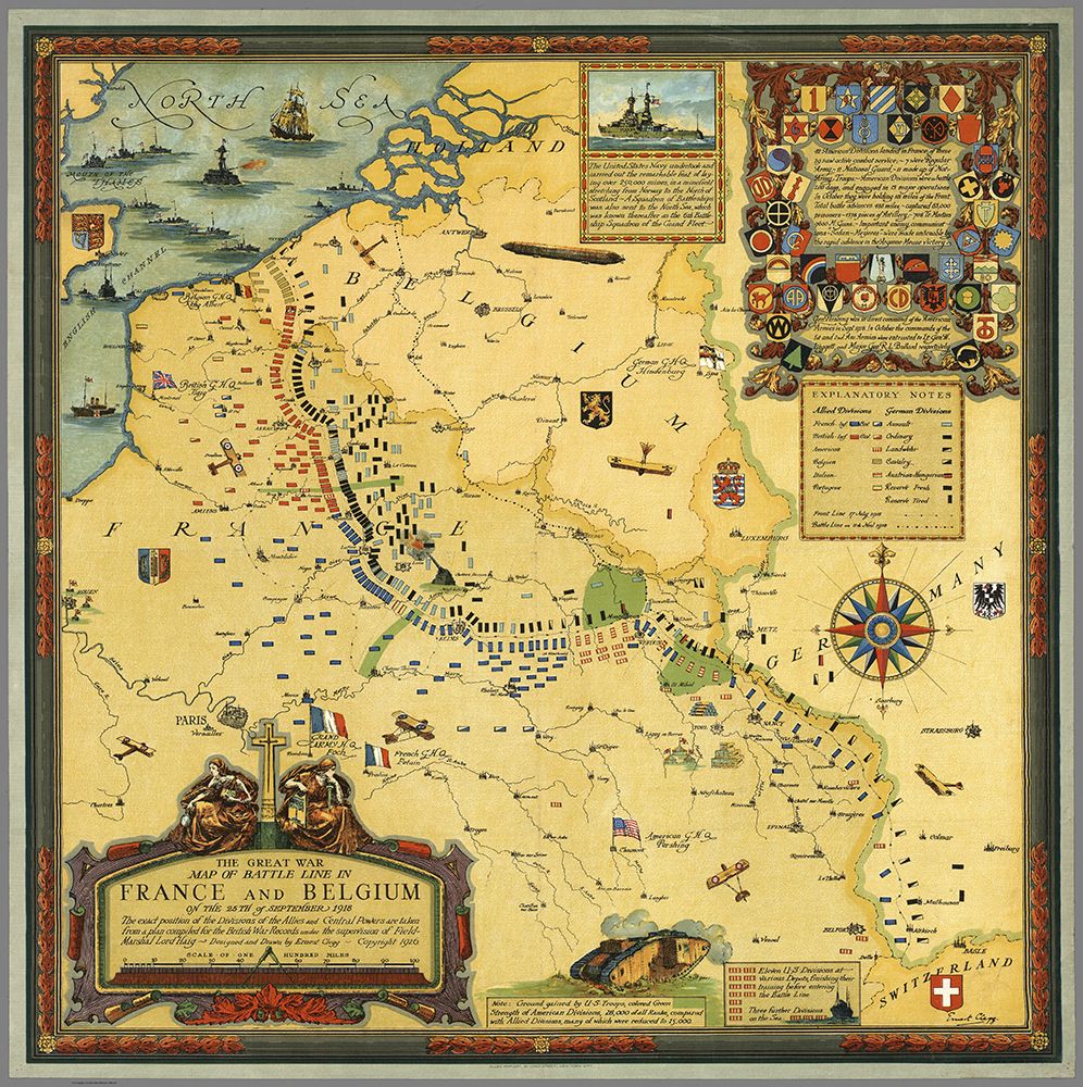
The Great War Map of Battle Lines in France and Belgium on the 25th of September 1918. The exact position of the Divisions of the Allies and the Central Powers are taken from a plan compiled for the British War Records under the supervision of Field-Marshall Lord Haig. Designed and Drawn by Ernest Clegg. Copyright 1926.

  • Galleries
    • Africa
    • Antarctica
    • Asia
    • Australia
    • Europe
    • + North America
      • North America
      • Mexico
      • Canada
    • South America
    • Middle East
    • World Maps
    • United States
    • + U.S. Cities and States
      • Alaska
      • Arizona
      • California
      • San Francisco
      • Colorado
      • Florida
      • Hawaii
      • Iowa
      • Kentucky
      • Maine
      • Massachusetts
      • Michigan
      • Montana
      • Nevada
      • New York
      • Oregon
      • Pennsylvannia
      • Rhode Island
      • South Carolina
      • Texas
      • Utah
      • Virginia
      • Washington State
      • Wisconsin
      • Wyoming
    • + National Parks
      • Denali Nat'l Park, AK
      • Glacier Nat'l Park, MT
      • Grand Canyon Nat'l Park, AZ
      • Rocky Mountain Nat'l Park, CO
      • Yellowstone Nat'l Park, WY
      • Yosemite Nat'l Park, CA
      • Zion National Park, UT
    • Pictorial maps
    • Timeline Maps
    • Mapping the Heavens
    • The Hysterical Maps
    • Military
    • Historic Ads
    • Oversized Maps

Copyright 2018 Cartography Associates.

Copyright © 2018 Reprint Mint Privacy Policy

Powered by

Powered by Reprint Mint