• Galleries
    • Africa
    • Antarctica
    • Asia
    • Australia
    • Europe
    • North America
      • North America
      • Mexico
      • Canada
    • South America
    • Middle East
    • World Maps
    • United States
    • U.S. Cities and States
      • Alaska
      • Arizona
      • California
      • San Francisco
      • Colorado
      • Florida
      • Hawaii
      • Iowa
      • Kentucky
      • Maine
      • Massachusetts
      • Michigan
      • Montana
      • Nevada
      • New York
      • Oregon
      • Pennsylvannia
      • Rhode Island
      • South Carolina
      • Texas
      • Utah
      • Virginia
      • Washington State
      • Wisconsin
      • Wyoming
    • National Parks
      • Denali Nat'l Park, AK
      • Glacier Nat'l Park, MT
      • Grand Canyon Nat'l Park, AZ
      • Rocky Mountain Nat'l Park, CO
      • Yellowstone Nat'l Park, WY
      • Yosemite Nat'l Park, CA
      • Zion National Park, UT
    • Pictorial maps
    • Timeline Maps
    • Mapping the Heavens
    • The Hysterical Maps
    • Military
    • Historic Ads
    • Oversized Maps
David Rumsey Map Collection

Cartography Associates

  • My Account
  • My Cart
  • Checkout
  • Log In
  • Help
  • Home /
  • Galleries /
  • Pictorial maps /
  • Alaska: Far North frontier, 1959
Alaska: Far North frontier, 1959
* Required Fields
Product ID  :  002-6822000
$39.95
Landscape

Width:

Height:

Move the crop points on the image below to view the image size and/or crop if selected.

Style description

Caption

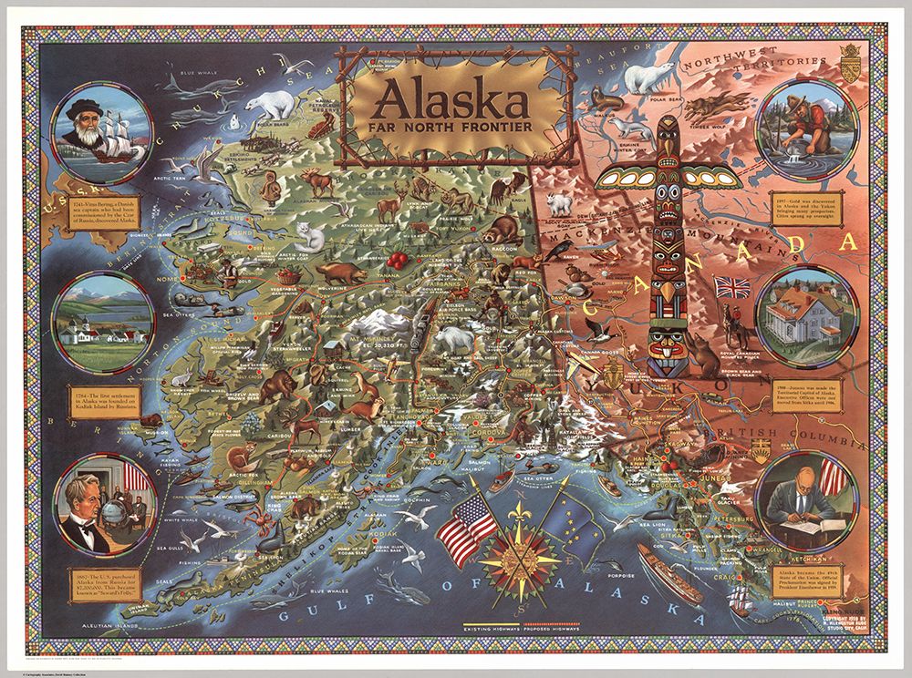
Alaska: Far North frontier. Copyright 1959 R. Klengston Rude
Color pictorial map of Alaska, published the year Alaska officially became the 49th state of the United States of America. Showing rivers, straits, sounds, towns, mountain ranges (drawn in aerial perspective), glaciers (shaded white), and existing and proposed highways. The map is richly illustrated with naturalistic depictions of wildlife, agricultural products, historical landmarks, oil fields and fisheries. Along the left and right sides, six circular illustrations highlight important events in Alaskan history beginning with Vitus Bering's 1741 explorations and ending with Alaska statehood in 1959. A compass rose over the Gulf of Alaska incorporates the American and Alaskan flags. Includes a section of the Canadian provinces of British Columbia, Yukon and the Northwest Territories to the east, which are depicted in less detail and dominated by a large illustration of a Native American totem pole. The map border is rendered in a geometric beadwork design, inspired by artwork of indigenous Northwest Coast tribes.

  • Galleries
    • Africa
    • Antarctica
    • Asia
    • Australia
    • Europe
    • + North America
      • North America
      • Mexico
      • Canada
    • South America
    • Middle East
    • World Maps
    • United States
    • + U.S. Cities and States
      • Alaska
      • Arizona
      • California
      • San Francisco
      • Colorado
      • Florida
      • Hawaii
      • Iowa
      • Kentucky
      • Maine
      • Massachusetts
      • Michigan
      • Montana
      • Nevada
      • New York
      • Oregon
      • Pennsylvannia
      • Rhode Island
      • South Carolina
      • Texas
      • Utah
      • Virginia
      • Washington State
      • Wisconsin
      • Wyoming
    • + National Parks
      • Denali Nat'l Park, AK
      • Glacier Nat'l Park, MT
      • Grand Canyon Nat'l Park, AZ
      • Rocky Mountain Nat'l Park, CO
      • Yellowstone Nat'l Park, WY
      • Yosemite Nat'l Park, CA
      • Zion National Park, UT
    • Pictorial maps
    • Timeline Maps
    • Mapping the Heavens
    • The Hysterical Maps
    • Military
    • Historic Ads
    • Oversized Maps

Copyright 2019 Cartography Associates.

Copyright © 2019 Reprint Mint Privacy Policy

Powered by

Powered by Reprint Mint