Composite: 1-164 San Francisco Aerial Views, 1938
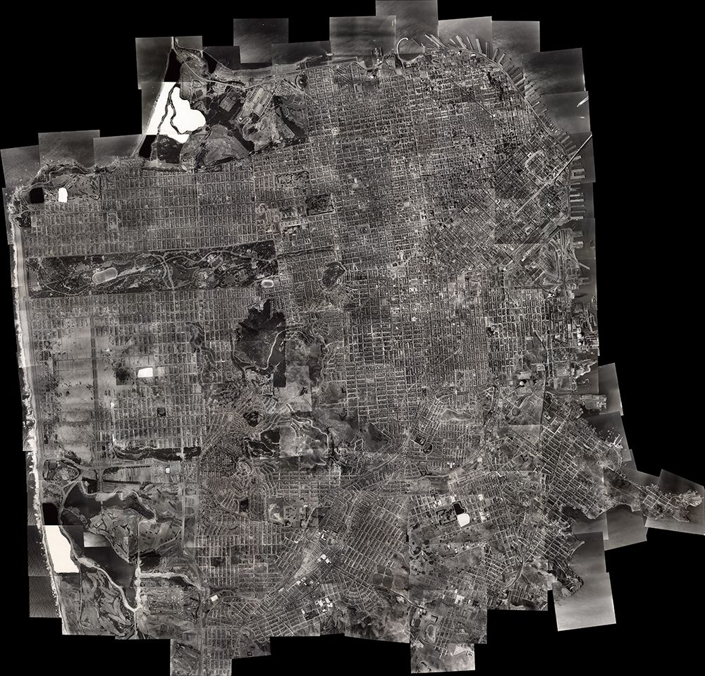
(Composite image of) Views 1-164 San Francisco Aerial Views. 1937-1938, Author Harrison Ryker Composite image of a set of 164 spectacular, large format, sharp, black and white vertical aerial photography partially overlapping images covering San Francisco north of a line approximately between Merced Lake and Candlestick Point. Resolution generally better than one meter and much higher with high contrast features, for example the paint striping on a basketball court. Relative heights frequently discernible based on shadow cast of objects and structures. Handwritten date on index map indicates photographs taken in August, 1938. Owned by the San Francisco Public Library. (Authorship almost certainly incorrectly spelled in handwriting on index sheet as Harrison-Rikker). He married Charlotte Seward in the mid-1920s; after divorcing, he married Esther Miriam Munson in 1936 Aerial Photographer Harrison Clay (Chesley) Ryker (1898-1981) was born in Oakdale, CA. . He served in the U.S. Army for several years in Germany with the post-World War I occupational forces, and partook of educational opportunities at the University of California, Berkeley. Expanding on his hobby in photography, Mr. Ryker teamed with various pilots beginning aerial photography services out of the Oakland Airport and throughout the West. Colleagues included Lage Wernstedt of the U.S. Forest Service. He also worked with the Fairchild Aerial Camera Company (including an aerial survey of Puerto Rico) and Clyde Sunderland of Pacific Aerial Surveys. As well, he took photographs of the devastating 1923 Berkeley Fire, archived in The Bancroft Library. By 1938 Mr. Ryker was listed in business as a map publisher (see Polk's Oakland 1938 Street and Avenue Guide) based at 1924 Franklin St., Oakland. At that time, he had at least one patent pending for a stereoscope used for aerial photograph interpretation. Shortly after 1938 Ryker established his company address as Harrison C. Ryker, Inc., at 1000 Ashby Avenue, Berkeley, California (relocating to east Oakland in the 1950s). He subsequently manufactured pocket and desktop stereoscopes and a vertical Sketchmaster, instruments that were extensively used by educational institutions and the military, especially during World War II. His experience in aerial photography led to further involvement in photo interpretation and cartography. An article in the journal The Timberman (1933) describes means of distinguishing individual species of forest trees on aerial photos; later applications were terrain analysis for petroleum geology and unmasking of ground camouflage during wartime. His largest product was the Wernstedt Mahan map plotter, patented in 1954, which was a standard cartographic device for its time. His instruments are in use today in libraries, air photo collections, and earth sciences departments throughout America; they are in the instrument collections of the Archives of the History of American Psychology, and the Institute of Geographical Exploration at Harvard University has the Ryker M-11 Reflecting Stereoscope. Among his patents were the (1) the adjustable pocket stereoscope filed with the United States Patent Office: Patented December 1940. Patent No. 2,225,602, and the (2) the stereoscope filed with the United States Patent Office: Filed September 1, 1937, Serial No. 161,973; Patented January 21, 1941, Patent No. 2,229,309. Harrison Ryker pioneered research in aerial photo interpretation. His work has been noted by A. Everett Wieslander, an early (1930s 1950s) leader in the mapping of California vegetation and soils, in his Oral History produced by The Bancroft Library, and in a letter by Robert Colwell, Forestry Professor at the University of California, Berkeley.