Official Map of Chinatown in San Francisco, 1885
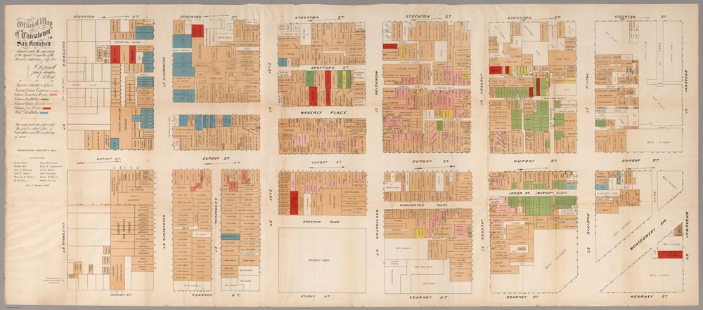
Engraved and printed by Bosqui Eng. & Print Co., San Francisco, 1885. First edition, first issue. Large folding map on two sheets, joined. Printed in colors. In 1885, at the height of the anti-Chinese hysteria in California, the official Report of the Special Committee of the Board of Supervisors was issued, reporting on the "Condition of the Chinese Quarter and the Chinese in San Francisco." This inflammatory report included the rare folding color map of Chinatown, but in the usual "small-scale" version (approx. 8½x19½ inches). This map was also issued in the San Francisco Municipal Report of 1884-85, and in Farwell's The Chinese at Home and Abroad (see our 5807.000). However, this first issue of this map was printed in a supersized version by San Francisco's first "fine press printer," Edward Bosqui. It was most likely printed for the use of key city officials. The map shows San Francisco's Chinatown, bordered by California, Stockton, Broadway, and Kearney Streets. It is color-coded to show every business, gambling parlor, houses of white and Chinese prostitution, opium "Resorts," joss houses, etc. It was printed on a scale of 40 feet to the inch. The differences in this large-scale copy and the smaller version are the list of Supervisors imprinted thereon, different type fonts for streets, etc, one mistakenly identified house of white prostitution (corrected in the smaller version as a house of Chinese prostitution, and the Bosqui imprint. This large-scale version is exceedingly rare. Only a handful of copies are known, most in institutional libraries.